RiverConnect Short Stories films 2016
Creation of two short educational and promotional videos that showcase the love of our Goulburn and Broken Rivers and reflected the local communities’ connection and appreciation of these systems.
Keep Victoria Beautiful – Sustainable Cities for Community Government partnerships Award 2016
Recipient of the Community Government Partnerships award in recognition of RiverConnect’s outstanding achievement in partnerships between community and any level of government.
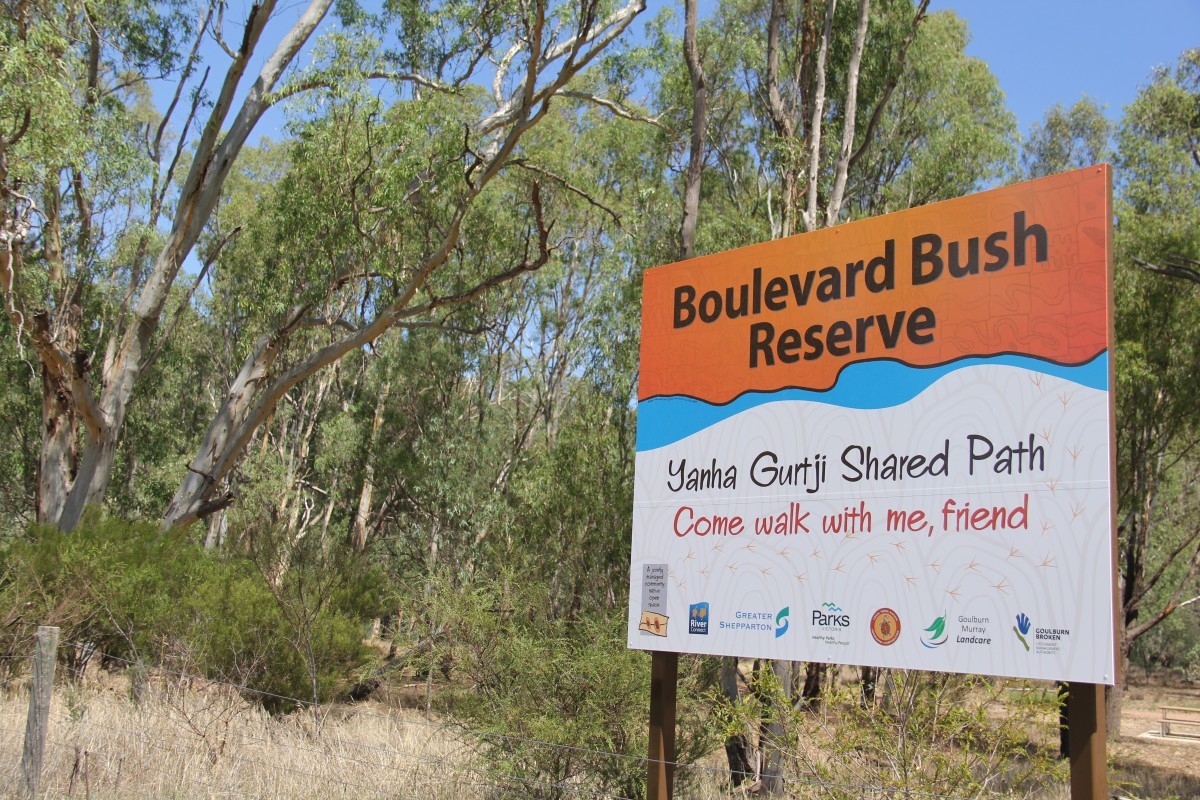
Boulevard Bush Reserve Signage
Increased visitor experience with a suite of signage developed featuring the Possum Skin Cloak artwork of highly respected Yorta Yorta, Mutti Mutti and Boonwurrung artist, Lee Darroch. Animal trail markers, interpretive signs and entrance were installed at the Boulevard Bush Reserve in 2015.


RiverConnect Celebrates 10 Years
Members, past and present, gathered at Western Park (Victoria Park Lake) to celebrate 10 years of achievements on Tuesday 15 December 2015.
Some took the opportunity to enjoy a gentle canoe paddle down the Goulburn River, before joining approximately 40 others to celebrate.
Speakers Lisa McKenzie, Cr Dennis Patterson and Chris Norman highlighted significant milestones after a traditional Welcome to Country and Smoking Ceremony from Aunty Ella Anselmi. The projects success was attributed to the ideal of the RiverConnect idea - connecting people to the Rivers, and the joint partnerships between agencies, organisations and community.
Rod McLennan and Bruce Cumming were acknowledged for their enormous contributions to the RiverConnect project for the past 10 years since the projects inception.
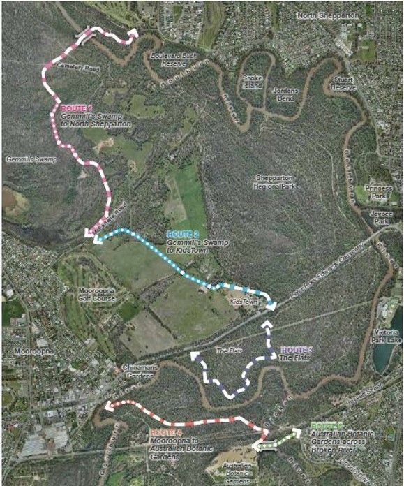
Launch of the RiverConnect Paths Master Plan 2015
The desire to increase physical linkages between Shepparton and Mooroopna and establish a greater connectedness of the natural environment, lead to the development of the RiverConnect Paths Master Plan. Funding was received from Regional Development Victoria and input provided via the RiverConnect Paths Focus Group and community consultation.
The Master Plan established 5 new paths of interest across the Shepparton and Mooroopna river environment:
- Route 1: Gemmill’s Swamp to North Shepparton
- Route 2: Gemmill’s Swamp to KidsTown
- Route 3: The Flats
- Route 4: Mooroopna to Australian Botanic Gardens
- Route 5: Australian Botanic Gardens across Broken River
The implementation of the Paths Master Plan will continue to progress dependent on external funding and overseen by the RiverConnect Implementation Advisory Committee and Council Officers.
Boulevard Bush Reserve Management Plan 2014
Bordered by the Goulburn River and The Boulevard, Boulevard Bush Reserve is a 13.6ha section of unique River Red Gum woodland which is utilised by local community members, community groups and schools as a passive recreational and educational space.
The Reserve has a good representation of native understorey plants and large old trees that support a variety of fauna species such as echidna, Azure Kingfisher and Squirrel Gliders. The Boulevard Bush Reserve Management Plan was developed in 2014 (and reviewed in 2019) as a collaborative and ongoing approach to management of the area.

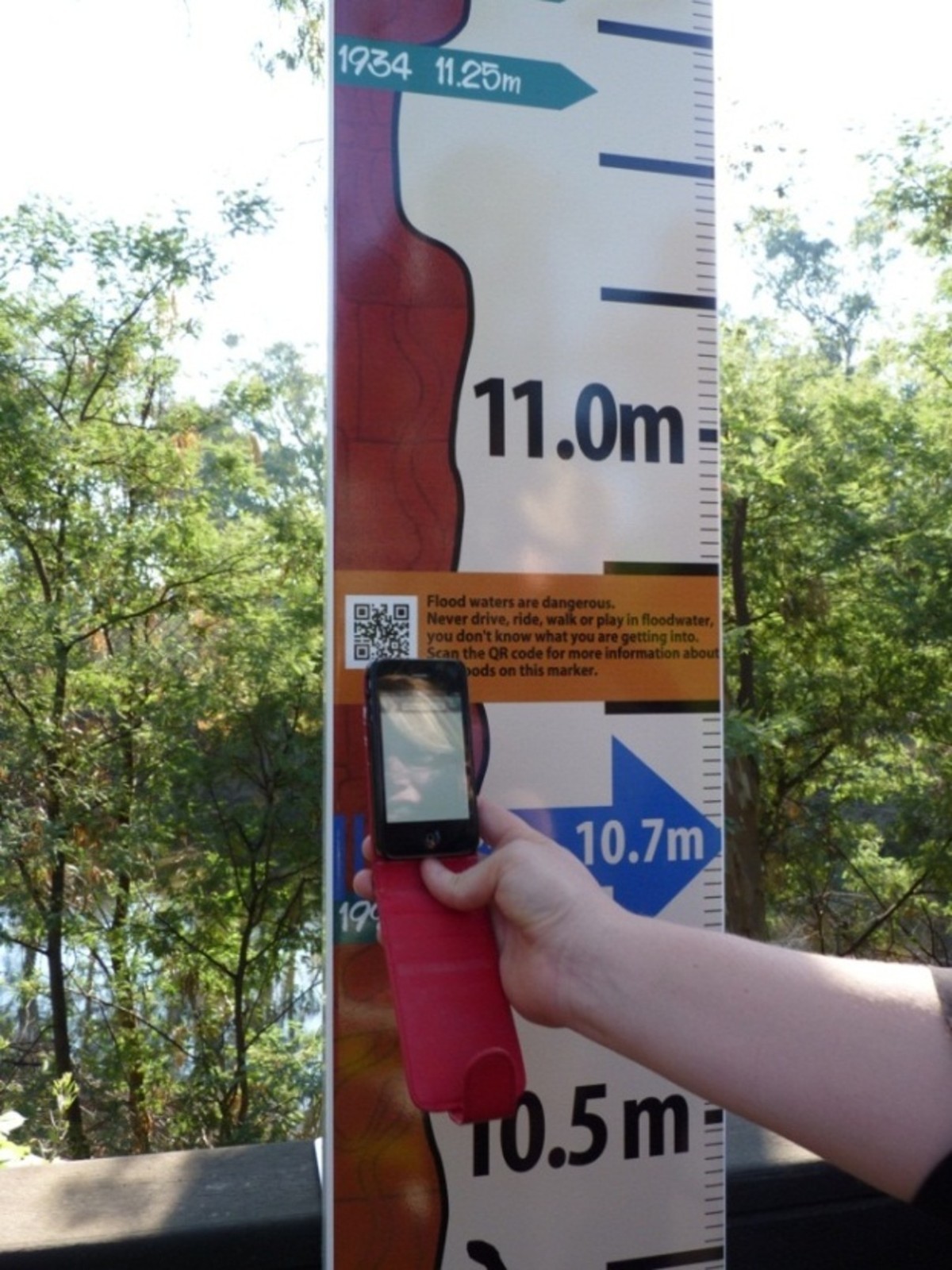
Installation of Historical Flood Signage 2014
Greater Shepparton City Council, SES, Goulburn Broken CMA, RiverConnect, Department of Environment and Primary Industries, Victoria Police, CFA, Ambulance Victoria and Red Cross partnered to produce the Historical Flood Markers, Flood Guide and Emergency Toolkit.
The Flood Signage are a community education tool, creating awareness of the previous flood levels, helping residents understand flood risk living close to rivers. Each sign includes a QR code to access a wide variety of historical flood information, available via the link below.
The Flood Signage has been installed in four locations:
- Viewing Platform – Murchison
- Dainton’s Bridge – Shepparton
- Chinaman’s Garden – Mooroopna
- Jackson’s Park – Kialla
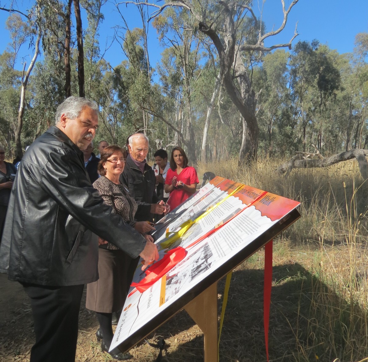
Launch of The Flats Interpretive Signage 2013
The Flats is a culturally significant area located on the floodplain between Shepparton and Mooroopna. The Flats Interpretive Signage was designed to inform and educate visitors and locals of the cultural significance of the area.
The two directional, one large timeline and six smaller event signs were developed in partnership between RiverConnect, Greater Shepparton City Council, Yorta Yorta Nation Aboriginal Corporation, Rumbalara Aboriginal Cooperative and Yorta Yorta Elders. Photos and records were accessed from local families and local and state government agencies.
The signage opened up opportunities for Yorta Yorta Elders to undertake guided Flats Walk tours, as well as for locals and visitors to venture on self-guided tours. Between May and December 2013, Elder Uncle Leon Saunders guided over 2,500 people on Flats Walks, utilising the signage for visual prompts and discussion points.